Murphy to Manteo: Finding new adventures, historic detours, and the soul of North Carolina on the state’s longest highway: U.S. Route 64. Read the series.
“There it is! Pull over!” I shout at Alex as we round a curve on U.S. Highway 64. Our target: the pull-off for Cullasaja Falls, a mighty 250-foot waterfall in Nantahala National Forest. What we didn’t know was that the pull-off is no more than a blink-and-you’ll-miss-it shoulder with barely enough room to fit three cars between this winding two-lane highway and the Cullasaja Gorge. My husband looks over at me incredulously as I point at the one remaining spot, which would require parallel parking.
For a brief moment, I glimpse part of the falls through yellow foliage as it flows down a cliff. Then Alex steps on the gas, and Cullasaja is in our rearview. Metaphorically speaking, that is, since we’ve gone around another curve.
“That can’t have been the right place,” Alex says confidently.
“That was the place,” I reply. “If you would just follow my lead!”
“What — off a cliff?”
I decide not to share with him that if we had stopped, the next part of my plan would’ve entailed a climb over the guardrail and a hike down a steep and unofficial trail to reach the base of the falls. We would’ve at least gotten a better look if we’d parked, but I determine that a drive-by most definitely meets our criteria for today’s waterfall adventure.
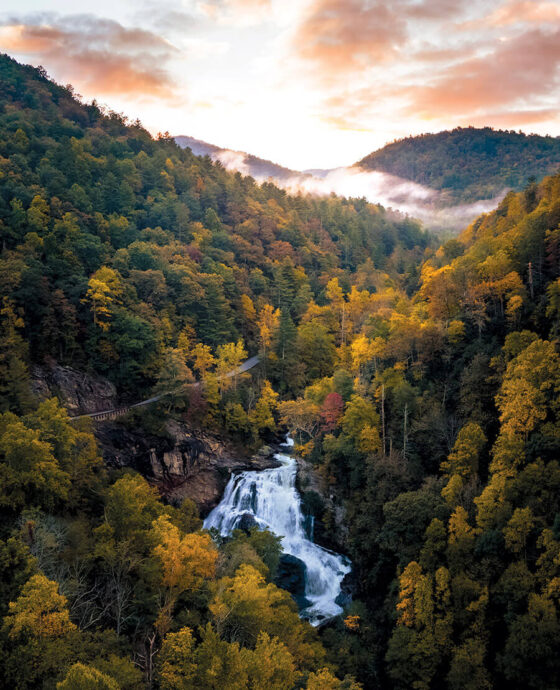
For nearly 100 scenic miles, from Murphy to Rosman, North Carolina’s Waterfall Byway follows U.S. Highway 64. It crosses through five of the state’s westernmost counties along a route surrounded by more than 200 waterfalls in every shape and size imaginable: grand cascades that plummet into deep pools, multitiered masterpieces hidden in the forest, delicate streams that free-fall over bluffs. Falls you can slide down, walk under, jump off. This area of our mountains is a veritable waterfall wonderland.
Most of these falls do require at least a little legwork to reach — sometimes that means an easy stroll down a short trail, but sometimes it means a technical and strenuous hike through national forest.
There are countless ways to venture off the byway to reach these falls, depending on your priorities. But Alex and I opt for a route we call The Car Potato’s Waterfall Agenda: a 19.5-mile stretch from Franklin to Highlands featuring three incredible waterfalls that can be viewed directly from the road — plus one work-for-it waterfall a bit farther east near the byway as a grand finale.
I sigh and mark Stop No. 1: Cullasaja Falls off the list.
Stop No. 2: Bust Your Butt Falls
Let me clarify something: It’s not that Alex and I are inherently car or couch potatoes. We’ve put miles on our boots together, hiking up to Torres Del Paine in Chile, deep into the San Juan Mountains in Colorado, and all over the Blue Ridge. We love a hike! But today is about chasing the soothing enchantment and drama of waterfalls — and maximizing the number we can see in an afternoon. Where else could you plan such a trip? Also, it’s going to rain. It’s one of those damp fall days when the sky is overcast and there’s a fine mist in the air and you want to be wrapped in a blanket. But, of course, you also want to leaf-peep. And therein lies the beauty of The Car Potato’s Agenda.
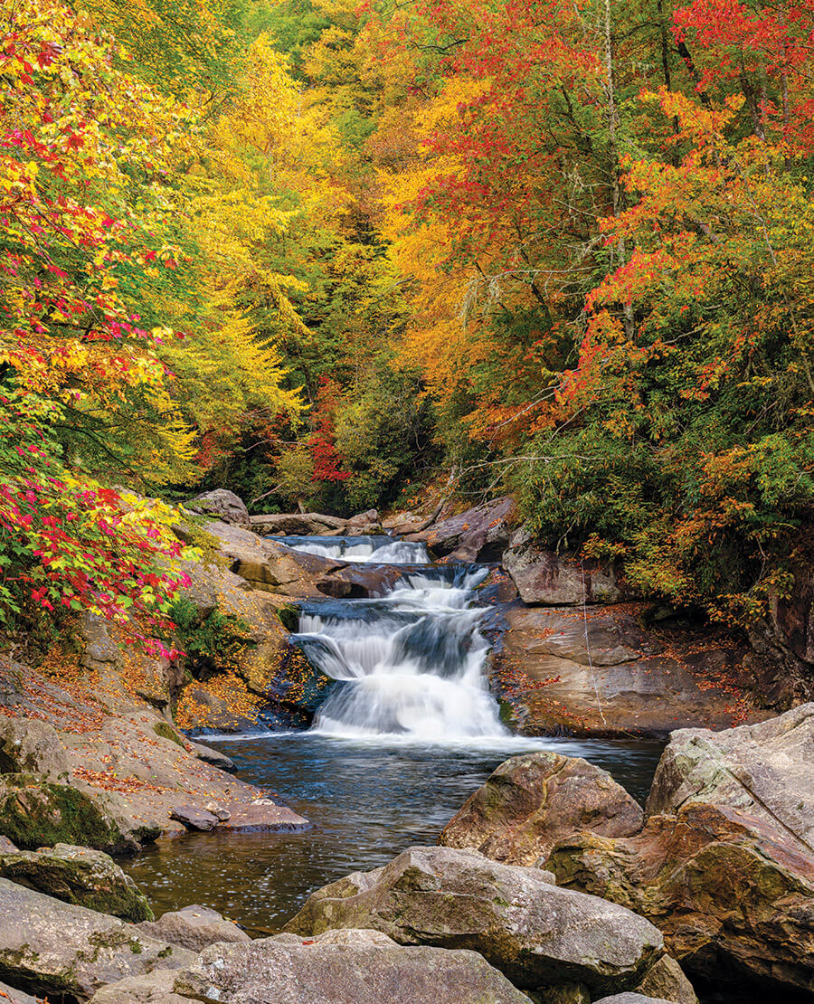
Just two miles after missing our first stop, we carefully — and successfully — park in the more accessible pull-off area for Bust Your Butt Falls (also known as Quarry Falls). Here, the Cullasaja River cascades along a series of small drops before flowing down a wide, slippery rock face into a pool. Perfect for sliding down 50 times in a row (if you’re 12), or, if it’s running high, simply taking a dip in the cool mountain water. However, because it’s a rainy day in October and we would most likely break something if we slid down a waterfall, we opt out of busting our butts. Instead, we view this beauty from an enormous boulder where, in the summer, I imagine I might lie in the sun like a cat.
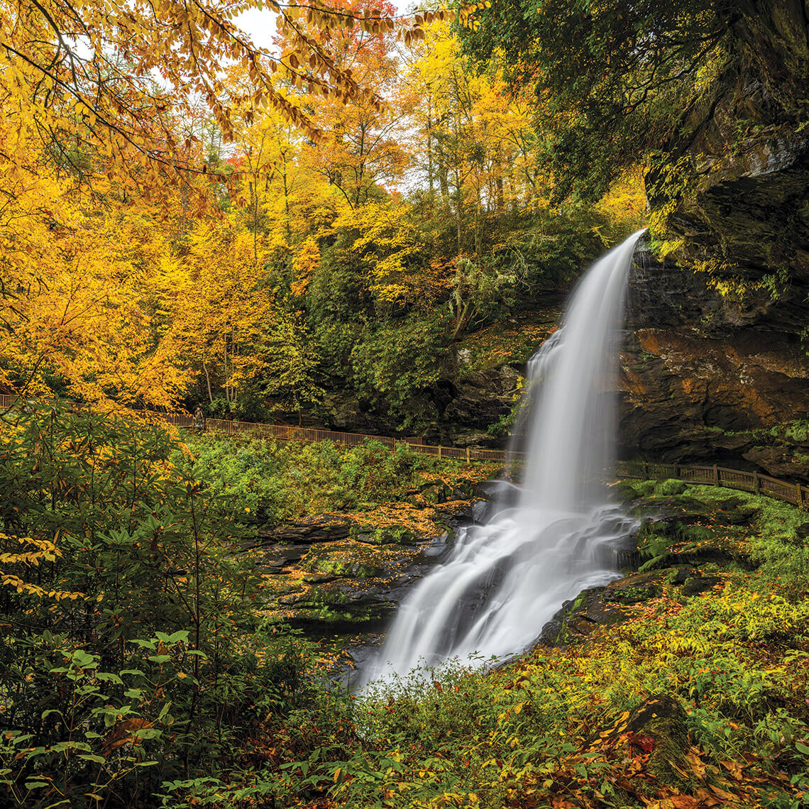
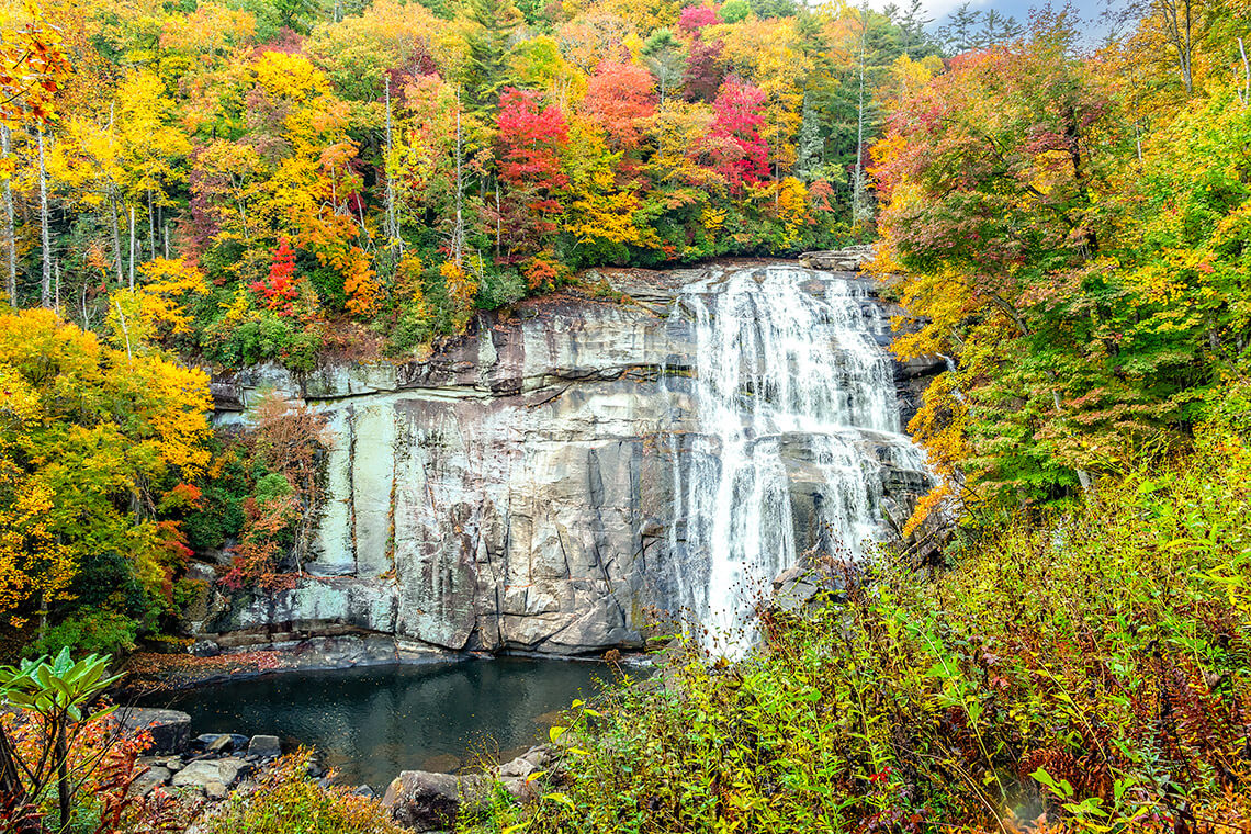
Stop No. 3: Dry Falls
A little more than three miles later, we reach the parking lot for Dry Falls. “Now this is a pull-off,” Alex says. We got our first look at this 75-foot waterfall from the byway. Now, at the first real viewpoint, we can see that it’s framed on all sides by trees with a million yellow and red leaves, some of which fly off their branches and do loop-de-loops in the breeze created by the rushing water. It’s like something out of a movie. But we’re struck most by the sound of it. “It’s like your white noise machine,” Alex says with amazement.
Much of the water is in free-fall, and we begin our descent down a long wooden stairway to reach the short, paved trail carved into the cliff behind it. It’s a route that even a car potato can’t resist. With each step we take toward the falls, the water seems to grow more alive.
And then we’re there, feeling very small. “After you,” Alex says, and we enter a different world entirely. There is only the roar of it, the soaking mist, the mossy wood railing and dripping rocks, the yellow leaves of the trees along the river beyond, and the relentless power of the water.
“I thought you said we’d stay dry!” Alex yells after me, but he’s laughing, and soon, I am too.
Rainbow Falls photograph by Ruth Peterkin/iStock/Getty Images Plus
Stop No. 4: Rainbow Falls
There are many other beautiful stops we could make along the byway — Bridal Veil Falls, Glen Falls, Cashiers Sliding Rock, Silver Run Falls, Whitewater Falls — but we continue east. After we reach Sapphire, we turn onto Whitewater Road and find Gorges State Park and the trailhead for a 1.5-mile hike along the Horsepasture River that will lead us to our grand finale: Rainbow Falls.
We leave The Car Potato’s Agenda behind and enter Pisgah National Forest on foot. We cross creeks and scale wooden steps, rocks, and roots until our thighs are burning. We sweat. After a day full of big payoffs with minimal exertion, this hike feels like a waterfall tax, and we welcome it.
Like Dry Falls, we hear it first. By the time the woods open up and we reach the viewpoint, what feels like a miracle has occurred: The clouds have broken, revealing one of those deep-blue skies you only see in October. Mist billows off the rocks below the falls. In the morning, in perfect conditions, the sun shines through, suspending a Technicolor rainbow in the droplets. We don’t spot it this late in the day, but it’s still breathtaking. Or maybe that’s just the final push it took for a car potato to get here.
I rest my head on Alex’s shoulder as we stare at the falls, both of us in a kind of post-hike trance. “You know,” I say, grinning up at him slyly, “if we hike just a little bit farther, we can actually add Turtleback Falls to our list.”
“I’m just along for the ride,” he says, grinning back. “Lead the way.”
More to Explore: Find our guide to 14 fantastic falls at ourstate.com/waterfall-guide.
print it