Editor’s Note: This story was originally published in 2013.
Today Cowans Ford Dam looks about like it did one Sunday afternoon in 1963 when our daddy piled my three younger sisters, my brother, and me into our white Rambler station wagon. We were just out of church and we drove north from Charlotte past Derita and Huntersville, down a country road — N.C. Highway 73 — to a vast and hot construction site. Steel trestles. Train cars. Miles of white. We all piled out and climbed to a concrete viewing stand. Daddy waved his arms and explained hydroelectric dams and how everything would be forever changed. He said the dam was 130 feet high, and he told us all about the water below, more than 32,000 acres of it covering houses and trees.
We got back in the car and drove north again to a wooded area way off the main road. We walked through the briars to look out. “When we get the road built, this will be our lot,” Daddy said. All we could see was a red clay field with tree trunks sticking up. But Daddy was waving his arms again. And there it was. The water from the Catawba River backing up to become Lake Norman. It had been inching its way up the 33 miles from that giant dam for months.
Underwater
Duke Power had been damming the Catawba River since the early part of the century to create hydroelectric power. Lake Norman was the final and largest of the seven lakes on the river, from just above Morganton down to where the Catawba joins the Santee-Cooper in South Carolina. Duke had been buying the land since the 1920s, and by the 1950s the company had almost all it needed for the project.
Duke bought land from Wib Overcash, who is now 86 and remembers well when the waters began to rise. Overcash sold 72 acres, land that had been in his wife’s family since the 1700s. Duke paid Overcash about $200 an acre, and in July 1963, Overcash brought his kids to camp on their new lakeshore. They had a 50-gallon drum for water, and no electricity.
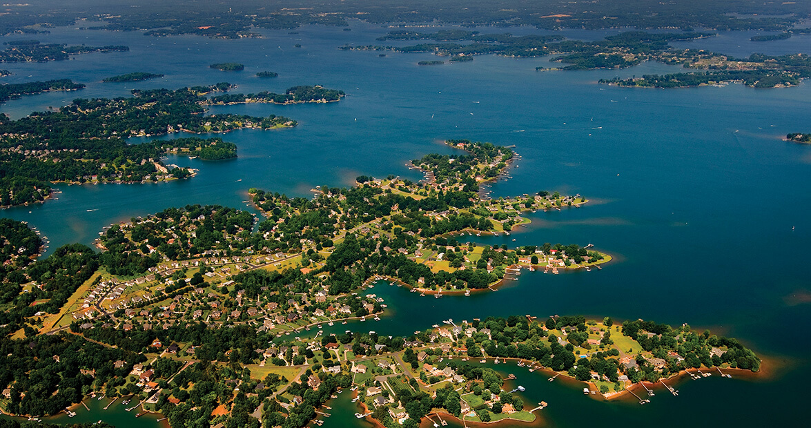
Overcash’s is just one example of a family whose land now lies beneath the waters of the lake, which turns 50 this year. In 1963, when the lake first began to fill, it swallowed farms, buildings, churches. The shoreline stretches 520 miles and the surface area is about 32,000 acres — the size of about 25,000 football fields. Its waters are in four counties. The lake is so massive, people call it the “inland sea.”
‘Prosperity gained’
The planning for Lake Norman began long before 1963. A Duke Power Company forester named Carl Blades walked every inch of those bottomlands, talking to the reluctant farmers who didn’t understand what was coming. The project meant moving cemeteries and homes. In 1957 plans were announced for building the dam at the historic Cowans Ford where Revolutionary War Gen. William Lee Davidson was killed. Gov. Luther Hodges visited in September 1959 to blast the first dynamite for the dam. Bishop Nolan Harmon of the Methodist Church was there to pray, “May the land lost prove prosperity gained.”
But the idea was first introduced in 1895, after the world’s first hydroelectric plant was built at Niagara Falls. William States Lee, a young engineer from South Carolina, was there working on the project and reportedly said, “Why can’t we do this back home on the Catawba River?”
In 1905, Lee and his friend Dr. Walker Gill Wiley met with James Buchanan “Buck” Duke, North Carolina’s tobacco and textile giant. When Lee and Wiley explained the idea of damming the Catawba River for power, Duke gave them a check for $50,000 to begin the Catawba Power Company (later Southern Power, then Duke Power, which changed to Duke Energy in 1997).
Lee’s great-grandson, States Lee, stands on a lake pier and recalls adventures with his father, Bill, who served as chief engineer for the lake and later as president and CEO of Duke. States and Bill surveyed the area, climbing through a hollow with pokeberries and briars. When Bill took out a 16-penny nail and hammered it into the base of a pine tree, he told States, then 6, what would happen. “When this lake fills up, it will be two feet below this tree. Now we know where to build our pier.”
By the summer of 1963, the water came right up to Bill’s pier. The new lake, named for Duke’s president, Norman Cocke, was the last link in a mighty power chain on the Catawba River. Lake Norman would provide electricity via the hydroelectric dam on the south end and by another coal-fired station, Marshall Steam Station, on the north, with plans for nuclear stations in the years to come. (McGuire remains the single nuclear power plant on the shore.) Lake Norman would provide flood control and fresh water for the four-county region. And in the years to come, it would become a recreational destination for thousands of people in the Carolinas.
Critters and caviar
Duke had predicted that the lake would reach full pond — 760 feet above sea level — in 1964, but heavy spring rains surprised everyone, and by the middle of July, the lake was full and open for business.
Families like ours could lease one-acre waterfront lots for $120 a year. Suddenly, people from all over Charlotte were coming to the lake to clear brush and build piers. The massive shoreline touched four counties — Mecklenburg, Iredell, Catawba, and Lincoln. Duke reserved much of the waterfront for future power sites. And there were restrictions on the lots that were leased. (Duke did not sell lots until 1977.) Private developers, some of them former farmers, established subdivisions with names like “Island Forest” and “Isle of Pines.”
Our family was part of that first pilgrimage of station wagons loaded with children and camping gear who drove up N.C. Highway 115 and U.S. Highway 21. Our lot was at the end of Brawley School Road peninsula in a place called Meck Neck. There was only one road in and it didn’t have more than 20 permanent families in the first three miles. In the middle of the peninsula was Morrow’s Chapel AME church, somehow untouched by the flood. Around another curve, we saw the abandoned cemetery for Williamson’s Methodist Church that had been moved to higher ground. After that it was one long, lonely seven-mile stretch of two-lane blacktop that ended in the water.
Enterprising Charlotteans opened businesses on the lake to serve the coming wave of people. Buck Teague and his family created Outrigger Harbor, complete with the Kon Tiki dinner boat. There was a paddle-wheel tour boat called the Robert E. Lee. Soon came Oni’s Landing, Country Corner Marine, Commodore, and Wher-Rena Marina. Our parents opened John’s Landing and John’s Trading Post, advertised as “Dealer in Most Everything.” This meant we sold both night crawlers and caviar. People brought their fish in to be weighed, and we took photos with a brand new Polaroid camera.
On a recent June morning I visited Lake Norman again. I drove to the Cowans Ford Dam, still imposing and white, and then headed to Brawley School Road, looking for anything familiar. The road is five lanes now, with flowering trees and sidewalks and a bike path all the way down the peninsula. I passed golf courses and mansions on streets named Andover, Southwick, Yarmouth.
Much has changed here. More than 17,000 people now call this peninsula home. Thousands more visit the lake every summer, and I know when they see that shoreline, they surely feel the same excitement I did when I first saw those waters rise.
Under Lake Norman
A lot lies under the water. To commemorate the 50th anniversary (in 2013) of the lake’s creation, Davidson College archivists created a website to document the land and structures that were covered in 1963.
Davidson archivist Jan Blodgett asked lake residents to share their images and stories, and listed the historical sites and structures online. The list includes a textile mill and housing community that once stood on the north end of the lake, and Elm Wood, a 200-year-old estate.
Other properties were razed because the lake was not planned to be deep, and Duke Energy thought bigger buildings would endanger boats, Blodgett says.
But some properties and roads remained. Part of the old U.S. Highway 21, which connected Charlotte and Statesville, is still there, under the water.
Lake Norman State Park
159 Inland Sea Lane
Troutman, NC 28166
(704) 528-6350