Trekking the Charlotte Rail Trail just off East Kingston Avenue, even the most ardent athletes pause at the gigantic chalkboard filled with scribbled words and phrases answering the prompt: “Before I die, I will …” One walker fishes out a wedge of chalk from the small dispenser and finds space in the chalkboard’s bottom left corner. “Be at peace with life,” she writes.
Here, along the Charlotte Rail Trail and on other urban trails throughout the city, her wish could easily come true. Mecklenburg County boasts more than 52 miles of developed greenway trails, with more in the works each year. Paths that wind through numerous nature preserves, past creeks and wildflowers, provide an escape into woodlands.
Whether you’re looking for a place to take a brisk run, a leisurely ramble, or an invigorating bike ride, Charlotte is one of the state’s best cities to explore by foot. Read on for the best places to lace up your shoes and hit the trails.
Charlotte Rail Trail
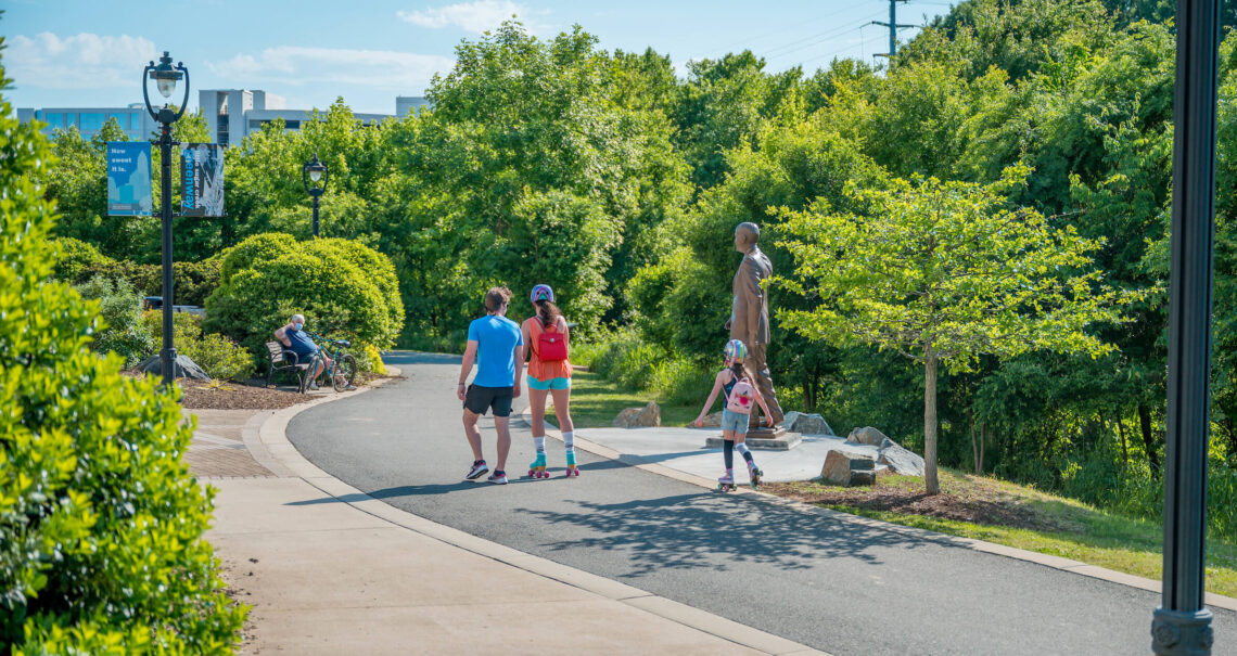
Depending on where you access the Charlotte Rail Trail, you might be greeted by a bold, 10-foot-tall exclamation point, whirligigs spinning in the breeze, or a porch with a funky, geometric awning and bright yellow swings. Wherever you land on this 3.5-mile trail lined with shops, restaurants, and apartments, you’re sure to find something a bit quirky.
Many of the trail’s art installations feature vibrant colors, and some are interactive, like the Rail Trail Symphony, a grouping of hand drums and chimes. In addition to the South End chalkboard, which spots are must-visits? “I have two favorites,” says Vica Bondurant, vice president of marketing and communications at Charlotte Center City Partners. “The Magic Carpet murals, because there is a cool view of Uptown, and the giant see-saw — because who doesn’t like a giant see-saw?”
Once a pedestrian bridge across I-77 is complete, this bustling trail will provide a continuous path that hugs Charlotte’s light rail track from 12th Street to just past Clanton Road.

You’ll find something quirky no matter where you land on the 3.5-mile Charlotte Rail Trail. photograph by Charlotte Regional Visitors Authority
Little Sugar Creek Greenway
If city skyline views were the only draw to Little Sugar Creek Greenway, it would be worth a visit. But this ribbon of green weaving through Charlotte is more than a series of photo ops. It follows Little Sugar Creek through neighborhoods and along roads, connecting shops, restaurants, and nine of Charlotte’s parks.
The northernmost segment of the greenway meanders nearly a mile and links Cordelia Park to Alexander Park. Be sure to keep an eye out for Gulf Coast spiny softshell turtles lazing in the creek.
The next stretch reaches more than four miles, from Central Piedmont Community College through Freedom Park to Brandywine Road. This landscaped urban section passes through plazas and parks with fountains, sculptures, and even a clock tower. On the “Trail of History” section, statues of prominent figures from the area’s formation offer a good place to rest.
The southern leg of the greenway stretches nearly five miles, from Tyvola Road to its end near I-485. As you move away from the bustle of downtown through this quieter terrain, you might hear the calls of barred owls or catch a glimpse of the hawks who call the greenway home.
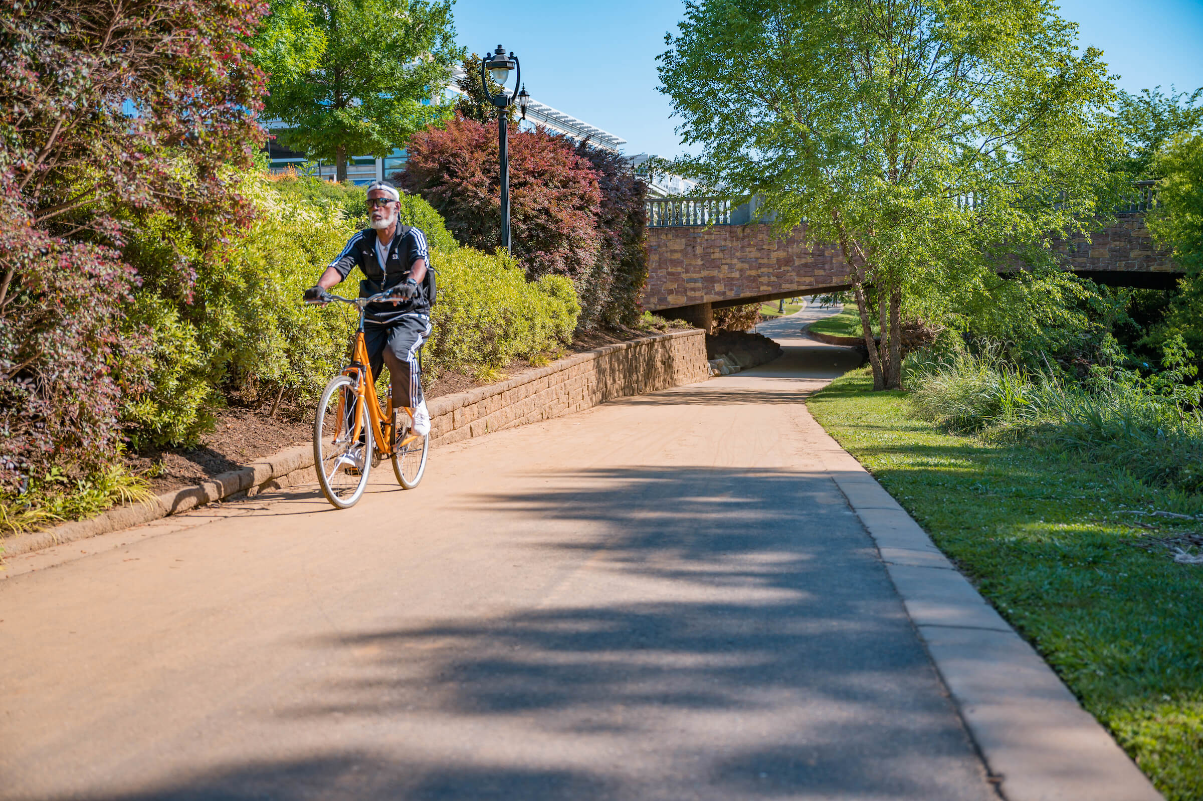
Little Sugar Creek Greenway follows Little Sugar Creek through neighborhoods and along roads, connecting shops, restaurants, and nine of Charlotte’s parks. photograph by Charlotte Regional Visitors Authority
Backyard Trail
For a more wild-and-wooded adventure, head over to Backyard Trail (BYT). Best known as a rugged and challenging course for mountain bikes, its 16.8 miles of trail are open to both walkers and hikers, and connect in multiple locations to the Little Sugar Creek Greenway.
“BYT was first started in the late ’80s by a group of bikers looking for a place to ride,” says Bryan Hall, president of Tarheel Trailblazers. Since it opened to the public in 2011, the Trailblazers have maintained the narrow, hand-built trail surrounding an old water treatment plant. The organization’s website also provides condition reports of BYT, which comes in handy after a rainy spell.
“It’s a one-of-a-kind mountain-bike experience in the center of Charlotte, including challenging technical trails, multiple jump lines, and even an opportunity to ride on narrow gauge rail tracks from the water treatment plant,” Hall says.
Reedy Creek Nature Preserve
At Reedy Creek Nature Preserve, more than 10 miles of trails travel through the dappled forest shade, past open meadows and lakes, and over gently flowing creeks. Outside the nature center, explore a backyard habitat garden certified by the National Wildlife Federation. Then, study the trail map.
One popular hike leads to the Robinson Rockhouse ruins, less than a mile from the nature center. Huge stone steps lead into the crumbling remains of a once-stately home. Completing the scene is an enormous fallen Osage orange tree, thought to have been planted in the 1770s, about 20 years before the house was built.
The Reedy Creek Nature Preserve protects the habitat of more than 100 species of birds and many other animals that make their home near the south fork of Reedy Creek. On your hike, keep watch for some of the preserve’s inhabitants, such as Kentucky warblers, spotted salamanders, and broad-winged hawks.
Anne Springs Close Greenway
Just 30 minutes south of the city center, Anne Springs Close Greenway sits on 2,100-acres of pristine former farmland. This greenway, nature preserve, and historic site’s Lake Haigler entrance provides easy access to the Greenway Gateway, where you can pay the day-use fee and pick up a map (visitors are welcome Monday through Thursdays).
From there, choose one of the greenway’s 26 trails. You could weave your way around the wooded shores of Lake Haigler or wind along the mossy banks of Steele Creek to a towering railroad trestle. Hikers can make use of all trails, but some are shared with mountain bikers, some with horseback riders, and others are for foot travelers alone.
Most of the trails have uneven natural surfaces, but the ¾-mile paved Nation Ford Loop that passes two log cabins — one built in 1780 by Billy Graham’s grandfather — is accessible to everyone. Other historic spots include a replica of the Garrison-Webb Gristmill, Fort Mill’s namesake, and a section of Nation Ford Road, part of the former Great Philadelphia Wagon Road.
If all that hiking makes you hungry, grab a bite to eat at the Gateway Canteen, suggests Elizabeth Bowers, the greenway’s communications director. “I love to tell people it’s the most beautiful happy hour in town — and probably in the state.”
Having trouble deciding where to start? Discover your own perfect trail with the interactive CLT Trail Guide, which offers six curated outdoor experiences to choose from, highlighting more than 22 miles of trails, plus accompanying neighborhood guides for each community you pass through.