Along the thread of sand that seems to dangle suspended between an expanse of Carolina blue sky and the vast indigo of the Atlantic, there is certainty in the uncertain.
On North Carolina’s barrier islands, what is here today can be gone tomorrow. A strong northeast blow can render the tangible ethereal. This sliver of land, whose resiliency is often mistaken for fragility, is unyielding and inflexible in its will to transform. It bows only to the mighty Atlantic Ocean. Her force of energy shapes the seaward dunes, molds the sound-side marshes, and shoves and tugs all that stands between.
This dynamic system is a not-so-gentle reminder of the endurance of impermanence. “Today a little more land may belong to the sea, tomorrow a little less. Always the edge of the sea remains an elusive and indefinable boundary,” Rachel Carson writes in The Edge of the Sea. Off the coast of North Carolina’s mainland, the only constant is change.
Links in a Chain
Bound by the Atlantic to the east and our estuarine system to the west, North Carolina’s barrier islands are giant deposits of sand transported by waves that bring sediment from the inner continental shelf. This system, one of the most dynamic on earth, hems in our sounds and creates harbored bodies of water that form marshes and provide critical marine habitats. They guard the mainland, defending it against the brutal force of the Atlantic Ocean during extreme weather events.
“Our barrier island system belongs to the ocean,” says Stan Riggs, a marine geologist who has been studying our coastline for more than 50 years. Riggs, now in his 80s, is a fast walker with a quick tongue that rattles off rates of erosion and accretion that span decades. He’s the type of scholar who looks as comfortable trekking across a beach or wading through a marsh as standing in a classroom.
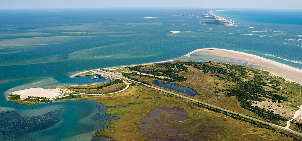
The four-wheel-drive section of Cape Point, looking across the ocean toward the Cape Lookout Lighthouse, offers a dramatic view of the wind and waves that shape our coast. photograph by DAN WATERS/DLWATERS.COM
“Wherever the ocean comes into contact with land,” he continues, “if there is sand and low topography, there will always be barrier islands. They are part of the ocean’s anatomy.”
The nature of their formation is where similarities between islands end. “No two barrier islands are the same,” Riggs explains. “They change in different ways and at different rates.”
These sloping piles of sand are not static beings: They are living, breathing ecosystems whose evolution is unceasing. As weather patterns change, winds shift, and sea levels rise and fall, barrier islands respond by morphing, transforming, and adapting.
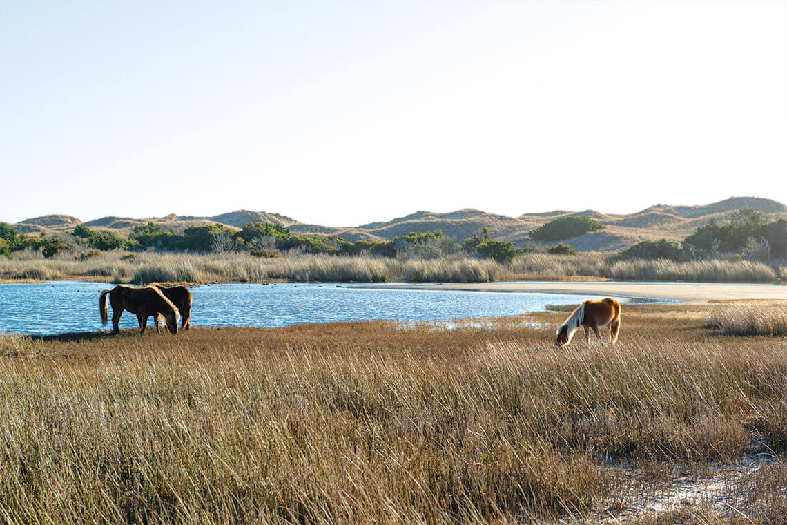
The wild horses of Shackleford Banks, the southernmost barrier island in Cape Lookout National Seashore, have learned to live with the elements. Over centuries, they’ve become part of the landscape themselves. photograph by Mike Basher
Karen Willis Amspacher, an advocate of coastal heritage and director of the Core Sound Waterfowl Museum & Heritage Center, grew up on Harkers Island but knew that her family had roots on Shackleford Banks, the barrier island to the southwest. The last residents left Shackleford Banks in the early 1900s. Still, she says, “that strip of land was and continues to be a part of our lives, an extension of our community and a connection to generations before us. Even as a child, I knew then it was part of my story. I knew it was sacred.”
She recalls noticing, each spring, how much hurricanes and winter storms had changed Shackleford Banks during the fall and winter. “We knew it was its own environment with its own capacity to ebb and flow, just like the tide,” she says. “A bad storm would come through, and it would cut a little inlet through the banks. But then, when the wind shifted, it would fill back in. It was constantly changing, and it still is.”
The March Westward
Despite the uncertainty of an island’s movement, the behavior of barrier islands has predictable characteristics. They evolve according to the laws of nature and depend on four factors: wave energy, availability of sand, the shape of the beach, and changes in sea level. If one factor changes, the others adjust to maintain balance. For instance, when wave energy and sea level increase during a storm or hurricane, the oceanfront beach flattens to displace energy across a broader surface. This dynamic equilibrium undergirds the system’s enduring will to persist.
As an encroaching sea threatens to inundate and drown these low-lying bars of sand, our islands fight to maintain their meager elevation and deliberately march westward, creeping across the sound, toward a recessing mainland shoreline. They’ve been migrating from the continental shelf for the past 10,000 years.
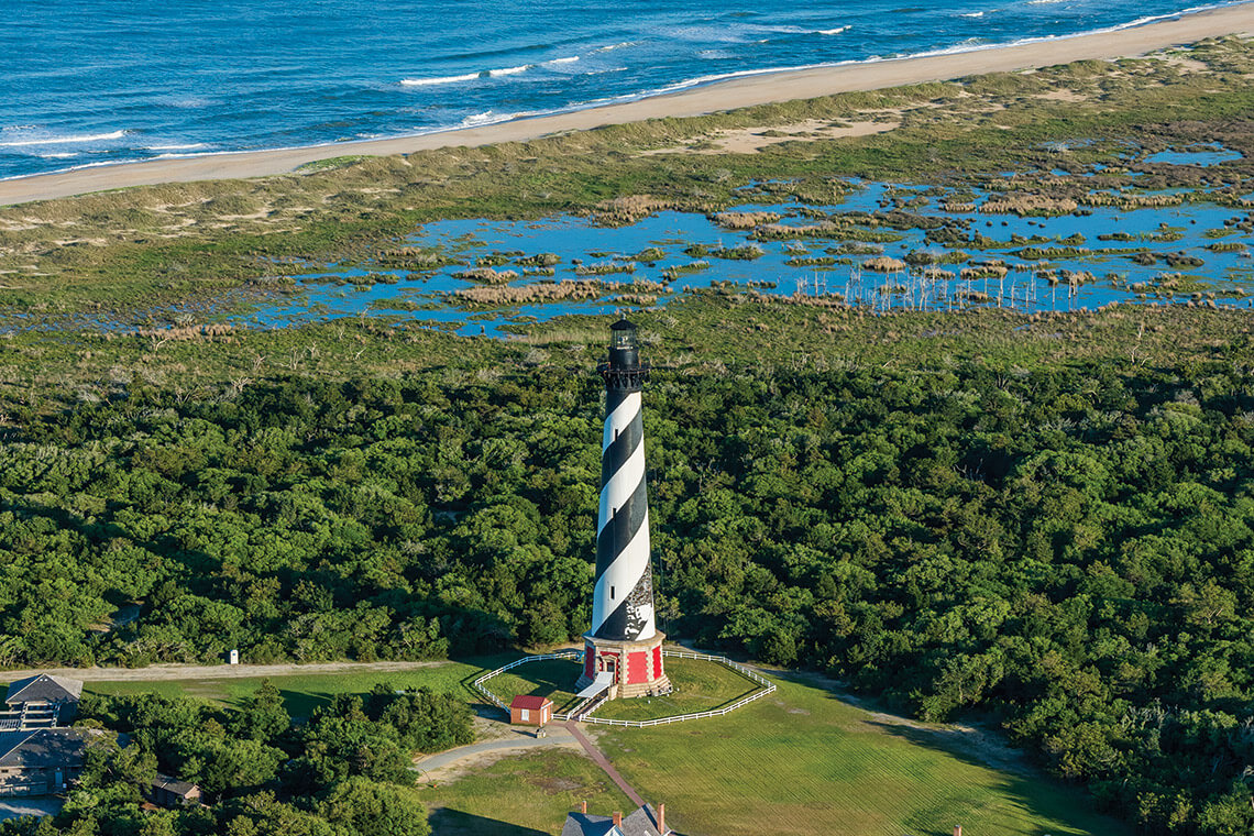
Cape Hatteras Light was moved to its current location in 1999. photograph by Emily Chaplin and Chris Council
By the late 1980s, erosion had brought the iconic Cape Hatteras Light within a perilous 120 feet of the ocean. In 1999, a high-profile move relocated the station to safety, 2,900 feet from where it had stood since 1870. photograph by Bruce Roberts
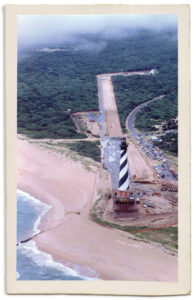
Signs of island movement abound, from sand whipping across NC Highway 12 on the Outer Banks to the opening and closing of inlets. In 1999, Buxton Village on Hatteras Island took center stage as officials at Cape Hatteras National Seashore oversaw the movement of Cape Hatteras Lighthouse. When the structure was completed in 1870, it stood 1,500 feet from the water’s edge. By the late 1980s, erosion had taken its toll, and the lighthouse was a mere 120 feet from the ocean. Over 23 days, the tallest lighthouse in the country was moved 2,900 feet from where it had stood for more than 125 years. Today, waves sometimes break across the original location.
A different fate has often befallen structures that were not relocated. Dwight Burrus, a seventh-generation Hatteras Islander now retired from Coast Guard search and rescue, recalls that when he was a boy, the old Hatteras Inlet Coast Guard Station stood on the north end of Ocracoke. It was abandoned in the 1950s because of erosion. “We watched the sea encroach on the station and take parts of the docks,” he says. “Then the boathouse. Then the main building. When the foundation collapsed, you could see the tower for a while in the water, and then, pretty soon, nothing. Now there are just pilings.”
Island movement makes itself known through both disappearance and revelation. The black oyster shells and large, orange-colored clams now scattered across ocean-side beaches may have originally inhabited the sounds. Riggs explains that as islands migrate landward, they expose shells that lived in the sounds several hundred or thousand years ago. In Corolla, waves often wash past groves of beachside stumps, remnants of an old-growth forest.
“It is a battleground,” Riggs says. “The ocean does not care about the land; it does what it’s going to do. It tears it up. It erodes it. It rebuilds it.”
The March Forward
The fickle spirit of the sea defines the geography of the barrier islands and shapes those who call them home. Those living at the water’s edge bear witness to the Atlantic’s seemingly unfounded savagery and bask in her gentle and generous nature, too. Like the islands themselves, people, too, have always adapted. From Indigenous islanders to colonial settlers to whalers at the turn of the 20th century, people have learned to live with hurricanes, winter storms, and the general unpredictability of life on barrier islands.
Battered by the storms of 1896 and 1899, residents of Diamond City, on the storm-wrecked Shackleford Banks, floated their homes across the sound to safer places like Harkers Island, Salter Path on Bogue Banks, and Promise Land in Morehead City. “They didn’t expect things to last,” says Amspacher, whose ancestors once lived in Diamond City. “There was no permanence in their lives. They lived with the elements. They had no choice.”
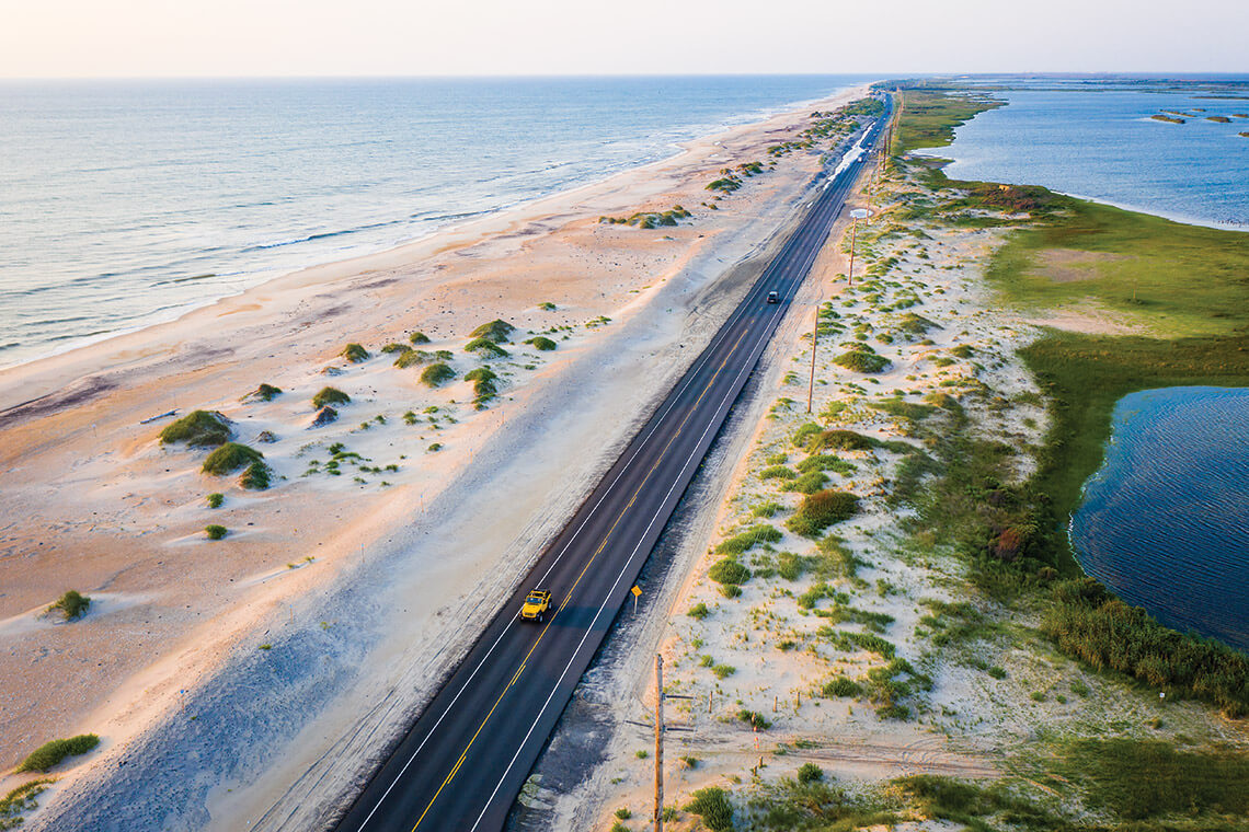
Signs of island movement are visible along the coast, such as the sand that whips across NC Highway 12 as it runs through Pea Island National Wildlife Refuge. photograph by Chris Hannant
Over the past half-century, our relationship with our barrier islands has shifted. A network of infrastructure and advanced engineering has provided never-before-known access, encouraging a new tourist-based economy and brisk development.
Today, buyers often seek oceanfront views, and we attempt to quell Mother Nature. We build higher dunes, install jetties, harden our shorelines, and pump millions of cubic yards of sand onto our beaches. “Our barrier islands have always changed, but the way we reconcile that has also changed,” Amspacher says. “My grandparents were accepting of their environment. It never crossed their mind that there was enough engineering or enough money or enough magic to stop the ocean. I’m not sure if there is today — nothing is guaranteed.”
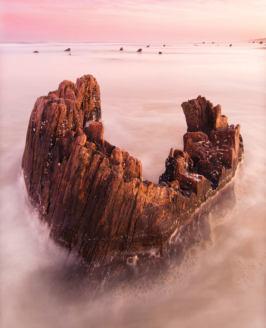
Strong winds and pounding waves reduce old-growth forests to weathered stumps in Carova. photograph by Jared Lloyd
To walk the shoreline along one of North Carolina’s barrier islands is to step out of the ordinary. These islands are where we seek refuge from the mundane and respite from the chaos. They renew our spirit and remind us of nature’s sophistication. They are the amphitheater to the stars and an observation platform to the depths of the ocean.
The stitch of sand running along our coastline is as curious and enchanting a place as anywhere in the world. Its beauty and geography defy definition, and its boundaries hold fast to mutability. Perhaps, in the islands’ elusive nature, lies their allure.