Editor’s Note: This story was originally published in 2019. Kate Dixon retired in 2022 after 15 years as Executive Director of Friends of the MST.
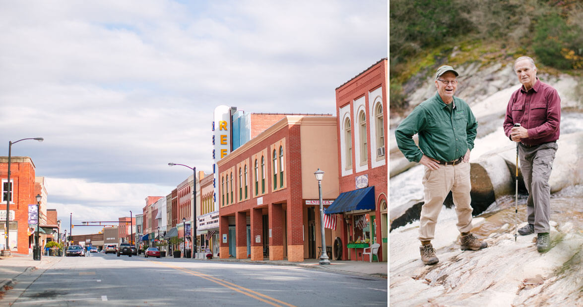
Bob Hillyer’s SUV has a Mountains-to-Sea Trail vanity plate on the back. Inside, it smells like Off! Deep Woods. When he gets out, he and his companion, Dr. Bill Blackley, slather themselves in bug spray, and Blackley begins to talk. Last year, a lone star tick bit him, and now he can’t eat any foods that come from four-legged animals without triggering a severe allergic reaction. No dairy. No meat. Possums eat ticks, Blackley says, and then he talks for 10 minutes about possums, until he is distracted by the splintering sound of something large and wooden crashing down close by. “A tree fell in the forest!” he says, because, get it? And then he goes back to talking about possums, and here, Hillyer gently interjects to say that they probably ought to focus on the trail.
The trail, at this point, does not exist here. Hillyer and Blackley follow its future path, starting at Preacher Field Road, just inside the Wilkes County line west of Elkin. Behind a winery are a few lonely graves under a tall walnut tree. One belongs to a man who was George Washington’s bodyguard. “Gonna highlight that when the trail runs through here,” Hillyer says. Then, they walk into the woods toward Big Elkin Creek, following the contour of a hillside. Hillyer has a roll of orange tape, and every so often, he’ll tie a bit of it to a tree, the knot facing the side where the trail will run. On gentle slopes with a grade of 5 percent or less, the trail can go pretty much where you need it to. If it’s steeper, it might need to zigzag or undulate over the terrain so that heavy rains don’t wash it out. On the steepest parts, you need a switchback. Hillyer has an inclinometer that he never really uses. “You can eyeball it,” he says, which, sure, he can eyeball it.
Hillyer trudges on, red mud clumping on his boots, leaves crunching underneath. Blackley follows, around a hillside, beneath the trees, pushing aside rhododendron and laurel. The orange flags start to form a route through the woods, toward the sound of rushing water. Hillyer ties one last orange knot before he and Blackley step into the open, onto a sandbar at the base of Carter Falls. The water rushes down, a white, frothy waterslide, some 60 feet from the top.
Listen as Jeremy Markovich hikes with Bob and Bill as they create a new section of trail:
For decades, this waterfall was hidden on private property, out of reach. To get here, you had to trespass. Some people did. Other folks, even in Elkin, didn’t know that Carter Falls existed. Pictures were hard to come by. The landowner let Boy Scouts camp here every once in a while. But that was it. Some eight years ago, Hillyer and Blackley, both members of the Elkin Valley Trails Association, got the idea to run a segment of the Mountains-to-Sea Trail (MST) in front of Carter Falls. The property owner, a longtime attorney in Elkin named Dan Park, said no. No no no, actually. Park had bought the property from Duke Power’s real-estate branch some 30 years ago because the land was beautiful and cheap. After he bought it, Park came upon a big rock at Carter Falls. On bad days or when he was in a contemplative mood, he’d sit on it and watch the water rush around him, the white noise soothing him, the fresh air reviving him. This spot was his and his alone, and he wasn’t going to give it up. Not to Blackley, or Hillyer, or any hikers.
For decades, this waterfall was hidden on private property, out of reach.
But then, he explains, something changed.
In his wood-paneled office in downtown Elkin, Park reiterates that his last name is not Parks, with an “s.” He’s gone out of his way to make sure that people don’t confuse it: He named his sons Lark, Mark, and Clark. His tropical fish is named Shark. He used to have a dog named Bark.
He’s now 85, but he’s still wily. Blackley, who seems to high-five every person he sees, tries to butter him up, saying that the Elkin Municipal Park and its series of trails — which double as MST segments — wouldn’t have been possible without him.
“Bull—t,” Park snaps, and everybody laughs.
Park explains his change of heart. His kids had moved away. Developers were circling the land. But Park had an eye toward preserving the place, to making sure that other people could enjoy it the way he had. So he picked up the phone. Run the trail, he told Blackley and Hillyer. A few months later, in December 2017, he sold the property to the state and donated 15 acres of adjoining land as an easement. “I’m stingy,” he says. “But I’m not stingy when it comes to my community.”
And thus, another mile of trail was painstakingly conceived. Now, it was up to Hillyer and Blackley to bring it into the world.

The Mountains-to-Sea Trail is 1,175 miles long. It runs from Clingmans Dome on the Tennessee border all the way to Jockey’s Ridge State Park on the Outer Banks, ending on top of whatever sand dune happens to be the tallest that day. The path in the western part of the state is almost exclusively trail, running across mountains and through forests on public land, winding over and around peaks until it reaches Stone Mountain State Park, 300 miles from the trailhead.
Then, things get complicated.
From there, the MST follows a lot of roads. It runs through towns, over sidewalks, back into woods, and then down asphalt shoulders, weaving its way along lakeshores north of Greensboro, on a riverwalk next to the Eno River in Hillsborough, along greenways around Durham and Raleigh, and down toward the Neuse River (where you can continue for 216 miles by kayak or canoe, if you wish). From there, it dips into the Sandhills, across the fall line into the Coastal Plain, and up toward Cedar Island. The last 81 miles or so are a combination of ferry rides, bridge crossings, and walks along the pale, sloped beaches of the Outer Banks.

North Carolina’s longest footpath runs 1,175 miles, from Clingmans Dome to the Outer Banks. Here are nine spots along the way that you need to see.
The MST follows trails in the west and roads in the east for a simple reason: It is exponentially easier to run a new trail across public land than it is to convince someone to let you build a trail across their private property. The largest swaths of national forest, parkland, and other public lands are in the west. Putting the trail in there was the easy part.
The nonprofit Friends of the Mountains-to-Sea Trail is helping take care of the hard part. They help plan and maintain the trail by organizing loosely affiliated groups of trail lovers in counties across the state. The trail is part of the state parks system, but it’s maintained by a patchwork of local governments and volunteers. Budgets are small. Volunteer time is finite. So the path appears a few feet at a time, wherever it can, thanks to the generosity of people who don’t mind a few hikers, and sometimes mountain bikers and horseback riders, crossing their land to attain a bigger goal.
So when people ask Hillyer when the trail will be completed, he answers: It is complete. We’re just changing it, bit by bit, to get it off the roads.
That, too, is the answer that Friends of the MST gives to the question it gets the most. “I say it’s done,” says Kate Dixon, the organization’s executive director. “We’re just making it better.”
At any given time, there are several dozen communities across the state that are in some stage of trail development, trying to organize engineering plans, easement paperwork, and crews of volunteer trail builders and maintainers. Places like Guilford and Orange counties are currently working out possible paths. A new bridge went in last year at Falls Lake. Soon, the trail will run across the Bentonville Battlefield. It is eking along at an average pace of about 15 miles of new trail per year. “There’s a tipping point,” Dixon says. “It’s very hard to get the first part of trail down. Then, people are like, ‘That’s wonderful — let’s add a mile to it.’”
At that rate, though, the MST will most likely never be 100 percent off roads. As such, Dixon and others have stopped referring to it as something that needs to be finished. Previously, in fund-raising pleas, Friends of the MST asked for money to help “complete” the trail. Now, they ask for money to improve it, to move it off the roads, to get it into the woods and away from cars. Such idealism, that a path already exists but could always be better, is on display in 19 counties, including Onslow, Pender, Carteret, Craven, and Cumberland. There, the Friends of the MST is helping install small road signs to show the trail’s route along eastern North Carolina’s back roads and byways. The words “Current Route” appear at the bottom, as if to say that the road is a temporary solution.
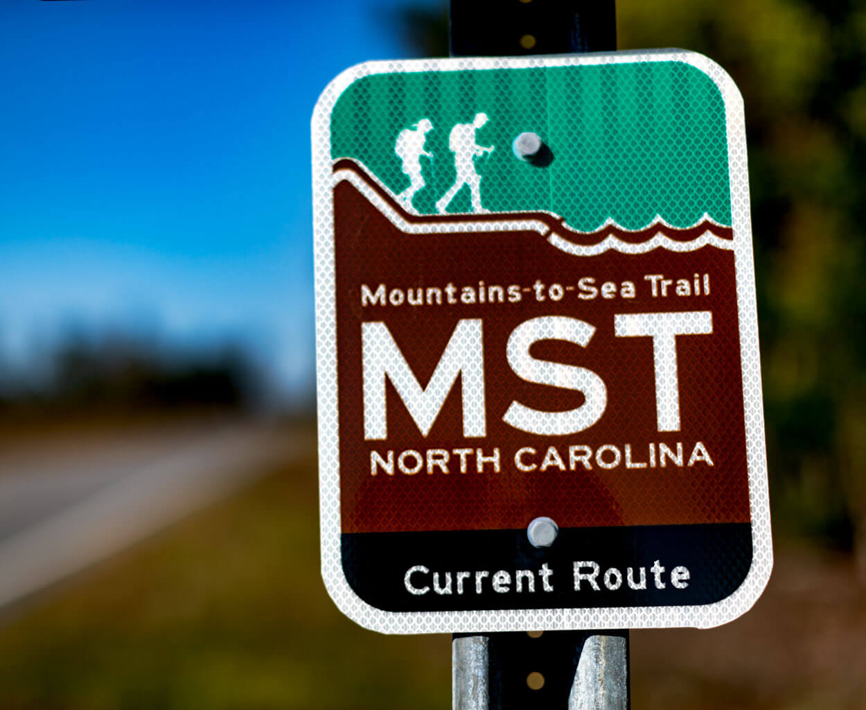
In areas where the MST follow roadways, brand-new signs let hikers know that they’re going the right way. photograph by Charles Harris
In eastern North Carolina, however, roads may be the only option in areas where the MST crosses swamps and wide rivers. Another impediment: It’s a region where hiking is not necessarily top of mind. “In that part of the state,” Dixon says, “there are so few hiking trails.”
It’s a challenge, but also an opportunity. The vast majority of people who hike the trail are day hikers, or out for a short trip. Hence, while the MST is generally thought of as a continuous footpath, it’s rarely ever used that way: Since its founding in 1977, just over 100 people have hiked its entire length. Instead, when new lengths of trail appear, it’s the locals who benefit most, because they now have somewhere to walk, run, hike, or bike that they didn’t have before. Plus, new miles of trail literally put their towns on the map, drawing in long-distance hikers from far and wide. Leaders in towns along the way are intrigued. “They want to know, ‘Can this really work?’” Dixon says.

Alice Butler was not a hiker, really. Not much of a camper, either. And then, the MST was rerouted through Roseboro, the Sampson County town where she’s mayor.
She still doesn’t camp or hike a lot.
Instead, she takes in hikers who need a place to stay, along a section of the MST where campgrounds are in short supply. Her contact information is on a list of trail angels — people who generously help thru-hikers. When she and her husband, Greg, get a call, they pick up the hiker, cook him or her dinner (“They’ll eat anything,” Butler says), and offer up their shower and washing machine. Later, they take the hiker back to the precise location where they picked him or her up. “They’re real sticklers about that exact spot,” Greg says, laughing. They don’t want to skip even a foot of the MST.
Many of them, like long-distance hiker Jennifer Pharr Davis, have expressed awe for this part of the hike. Here, the MST winds its way through farms; wet lowlands; and fields of blueberries, cotton, and tobacco. You can stop and talk to a farmer. The trees are gone, replaced by wide-open spaces and sounds that travel for miles.
It feels like a revelation, if only because it’s largely undiscovered country for hikers. Sampson is one of the largest counties in North Carolina by land area, but it contains no state parks. No trails. No bike lanes. For walking, biking, or jogging, there are only narrow asphalt shoulders and the occasional sidewalk. In Sampson County, the great outdoors are less than great when it comes to accessibility.
Butler is working to change that. She’s been in contact with Friends of the MST to try to move a section of the path off of local back roads and into the Pondberry Bay Preserve, a swath of state-owned land just north of Roseboro that’s home to the endangered pondberry shrub. The state’s been hesitant on account of the sensitive plant life there, but the hope among Butler and others is that the trail will actually help a piece of land that locals tend to tromp across anyway. If you give people a path, they’ll mostly stick to it.
And then, everything might snowball. Build one trail, and locals will want to make it longer. Have it connect to more things. Then, people will come to it. Right now, only thru-hikers come through town, and in the three years since Butler and her husband became trail angels, only about 10 people have spent the night at her house. Only 20 or so more have asked her for a ride. A dedicated trail might attract day hikers from around Sampson County and beyond. It might make the community healthier. “You want everybody to leave your town with a good feeling,” Butler says.
What could someday happen around Roseboro is already happening in Elkin, which has embraced the trail and is trying to expand it. Already, there are MST stencils on the sidewalk where the path runs down Main Street. A small but reliable stable of Airbnb rentals accommodates hikers. And every day, a little more of the trail is moved off the road and into the woods.
That’s thanks in large part to Bob Hillyer. He grew up in Asheville, where his father, John, cut trails through the woods and cowrote a book about the early history of the Mountains-to-Sea Trail. From him, Hillyer learned how to solve problems in thoughtful ways. Once, John asked a woman for permission to run a trail across her property down by the creek. It was the best place, he explained. She refused. The woman had scattered her husband’s ashes there, and she wanted that place to remain sacred. So John thought a bit, and then offered to install a memorial bench in the spot, to honor the woman’s husband and give hikers a moment to think about him as they rested. The woman was taken with the idea. The trail, and the bench, went in.
Hillyer, who retired from a career in business 12 years ago, is now doing that work himself. Around Carter Falls, he plans to add a bench to honor a young man who died before his time. He’s farming out trail tasks, like fence- and bridge-building, to aspiring Eagle Scouts. Overall, he hopes to extend the trail out from Stone Mountain, across Wilkes and Surry counties, connecting it to Elkin and beyond. To do that, Hillyer needs to solve a series of small problems, one piece of private property at a time. He talks to a lot of people. Knocks on doors. Most folks hear him out, even if they ultimately say no.
“You want everybody to leave your town with a good feeling.”
If enough of them in a row say yes, Hillyer gets them to sign easement papers, then figures out where the trail should go. Unlike at Carter Falls, the trail usually doesn’t take the best or easiest route: Most folks prefer it to run across the back of their property, out of sight, and that can make for some tough choices. Still, hundreds of conversations and dozens of signatures have allowed Hillyer to run the trail for a few miles. Grants here and there have meant that he can put in some bridges. He can’t pay for land or easements — that would set a bad precedent. Also, he doesn’t have the money.
So the trail is like a meandering creek, slowly moving down the path of least resistance. Hillyer only has two goals: that the trail run across Wells Knob — which is like Pilot Mountain without the dramatic cliffs — and past Carter Falls.
Already, a trail that leads from a parking lot on Pleasant Ridge Road, along an old road bed to the bottom of the falls, is complete and open. It was dug out by volunteers and quickly discovered by families, joggers, and dog walkers, many of whom greet Blackley and Hillyer by name. But the rest of the path across the creek and up to the other side of the property is still a work in progress.
Blackley and Hillyer have drawn up plans for a 200-foot suspension bridge to cross Big Elkin Creek, and it might take a year or two before that’s finished. They need grants, approval from the state, volunteers, and money. It takes a lot just to do a little. But the result at Carter Falls will be spectacular. A place hidden to most people for decades will soon become a destination.
All of that requires plenty of know-how, orange tape, and frequent walks through the woods. On the way back up the hill, Hillyer eyes one of the flags that he left tied to a small hickory tree. He furrows his brow, unties the ribbon, and attaches it to another tree. It’s a better route, he says. It follows the natural slope of the hill. Less steep. Won’t be washed out as badly. Then, he pulls down a vine. He adjusts his feet. Waits for a bit. “See?” he says to Blackley. “This is why you never take a trail builder on a hike with you.” It takes time to create a new way forward.