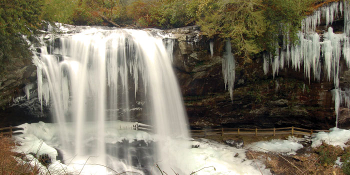
When the last leaves fall in western North Carolina, the landscape changes. Trees, once turned out in orange and red foliage, dress down for the winter. Waterfalls, once surging, slow and crystallize in the chill. Everything, it seems, is solemn and minimal and beautiful.
Then there’s the added benefit that travelers, once abundant and hurried, are fewer and at ease.
So any sunny day between January and early March is a good day to take one of North Carolina’s best mountain drives: the Waterfall Byway.
Part of the Department of Transportation’s network of scenic byways, this stretch of U.S. Highway 64 curves and climbs for 98 miles through some of the state’s westernmost counties. As its name suggests, the route passes near several waterfalls, all of which form icicles in winter. The full route — beginning in Transylvania County and ending in Cherokee County — is about a three-and-a-half hour drive.
But if you’re looking for the best views in the least amount of time, here’s a suggestion: Drive the byway between Highlands and Franklin.
This 19-mile section passes three waterfalls, two of which can be seen from a car.
The first, Bridal Veil Falls, is about four minutes north of downtown Highlands. You can literally drive your car behind this waterfall’s 120-foot drop, weather permitting.
About a minute north of there, you’ll find the parking lot for the second — Dry Falls. Locals claim that you can walk underneath this waterfall without getting wet, but to test that you’ll have to leave your car. And risk damp clothes in winter. A new viewing platform provides the view without the hassle.
The third, Cullasaja Falls, is a little more than five miles north of Dry Falls. To see it, you may have to pull off the road; be mindful of passing traffic here.
This shorter route takes about 30 minutes, not including the time you linger at each stop and forget about the hour.
U.S. Highway 64 Waterfall Byway
For more information:
(919) 733-2920
ncdot.gov/~scenic
—
Jeffrey Turner is the assistant editor of Our State magazine. See a list of all his archived stories.